Atlantic Circular: The Gulf Stream and its role (Part 1 of 3)


· 9 min read
This is part one of a three-part series on Atlantic Circular.
Western Europe is warmer than America or Asia at the same latitudes. From our school days, we seem to know why – Europeans were lucky with the Gulf Stream, a warm Atlantic current. Therefore, headlines that it is slowing down read like a prophecy of Europe’s imminent “climate decline.” But everything, of course, is much more complicated.
On April 22, 1513, the Spanish conquistador Juan Ponce de Leon wrote in his ship’s log: not far from the coast of the Florida Peninsula, his ships were caught in such a strong current that they could not move forward even despite a tailwind. This is the first written mention of the Gulf Stream, although it was probably known to residents before the appearance of white sailors in these parts. Six years later, the navigator of the same expedition, Anton de Alaminos, deliberately took advantage of the power of the Gulf Stream and returned to Spain with Cortez’s gold in record time. So the Gulf Stream turned into a transatlantic bridge through which Europeans exported gold from America.
The first map of the Gulf Stream was drawn by Benjamin Franklin and Timothy Folger in 1769–1770. The name “Gulf Stream” itself – that is, “the current of the gulf” – appeared on maps in the first half of the 19th century.
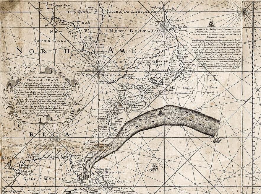
Map of the Gulf Stream drawn by Benjamin Franklin in 1769–1770
In 1855, the American naval officer Matthew Maury published the book “Physical Geography and Meteorology of the Ocean,” where he seems to have been the first to put forward the idea that it is the Gulf Stream that carries the heat of the Gulf of Mexico (where “otherwise it would be excessive”) to the shores of the Old World and thus improves the climate of the British Isles and throughout Western Europe. Since then, the idea that it is the Gulf Stream that “warms Europe” and determines its mild winters has penetrated scientific articles and textbooks.
Today, even Wikipedia reports: “On its way to Europe, the Gulf Stream loses most of its energy due to evaporation, cooling and numerous side branches that reduce the main flow, however, it still delivers enough heat to Europe to create a mild climate unusual for its latitudes. “ School geography textbooks are even more categorical: “Without this warm current [the Gulf Stream], Europeans would freeze.”
If you look at maps of surface currents, especially simplified ones, it seems that the Gulf Stream flows like a wide river directly to the shores of Europe (at the same time, no one is confused by the fact that on these maps it is combined with the North Atlantic and Norwegian Currents).
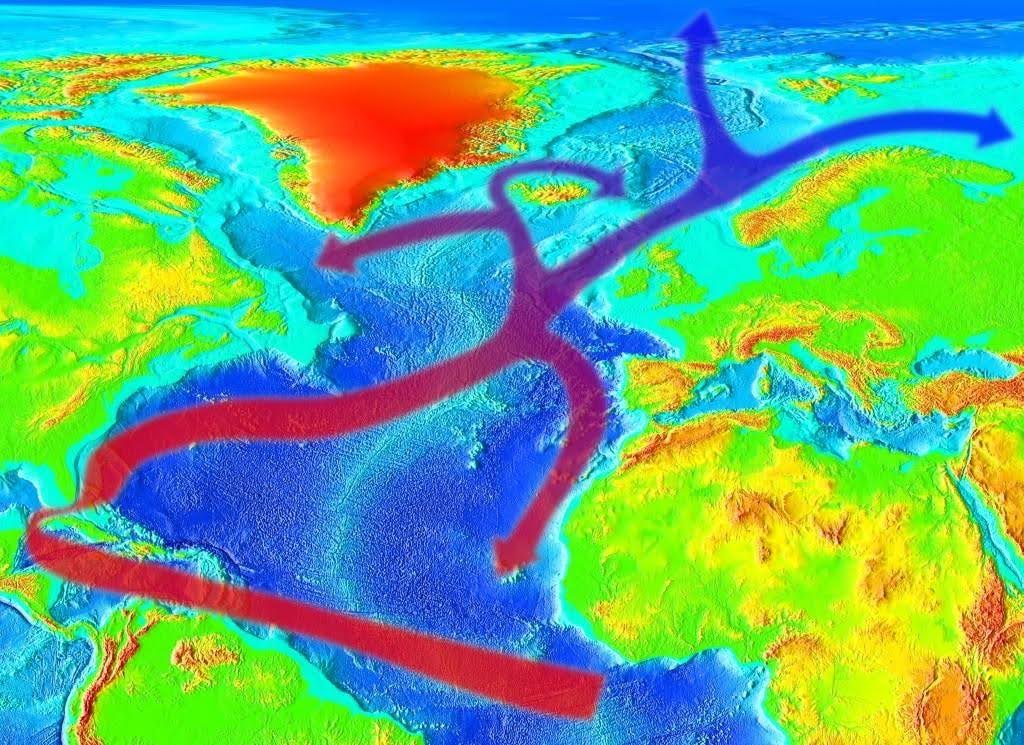
Schematic representation of heat transfer by the Gulf Stream, as used by Wikipedia. RedAndr / Wikimedia commons / CC BY-SA 4.0
But in a strict sense, of course, no natural heat-conducting pipeline has been laid across the Atlantic. The Gulf Stream moves north along the American coast and at Cape Hatteras, it turns somewhere towards Europe. But what happens to him along the way? And is it the heat that Europe receives?
The sun heats the Earth unevenly: the equator receives more, and the poles receive less. This temperature gradient is one of the main forces that drive the ocean and atmosphere. In the tropics, the climate system of our planet receives energy, and in temperate and polar latitudes it releases it.
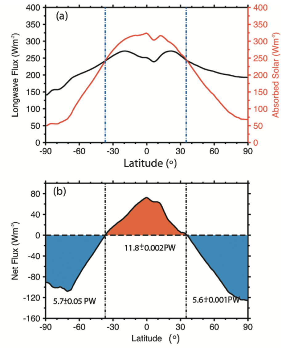
Average annual absorption of solar radiation at different latitudes (red line) and outgoing long-wave radiation (black line). Bottom: total radiation flux and radiation balance values in petawatts. Northern latitudes are on the right, “positive”. Graeme L. Stephens et al. / Reviews of Geophysics, 2015
In 2001, by linking observational data on the radiation balance at the top of the atmosphere and data on atmospheric transport, scientists showed that the main heat transfer from the equator to the pole occurs in the atmosphere. The ocean is a slow-moving component of the climate system. It does not respond as sharply to external influences as the atmosphere. In heat transfer, it acts as an accumulator: receiving heat from the Sun and heating up, the ocean then shares it with the air (directly for solar radiation, the air is almost transparent).
The atmosphere picks up the heat and moisture of the ocean (moisture condensation leads to the release of heat, which means the transfer of moisture is, in fact, also the transfer of heat, only “hidden”) and carries it from the tropics to the poles. The water itself transfers much less heat to the poles than the atmosphere; their contribution is comparable only closer to the equator. The maximum heat flow is achieved at 30–40 degrees latitude, and on average per year is six petawatts (in the winter months it reaches eight petawatts). In the Atlantic, maximum heat transfer by the ocean occurs in the region of 15 degrees north latitude and does not exceed 1.2 petawatts.
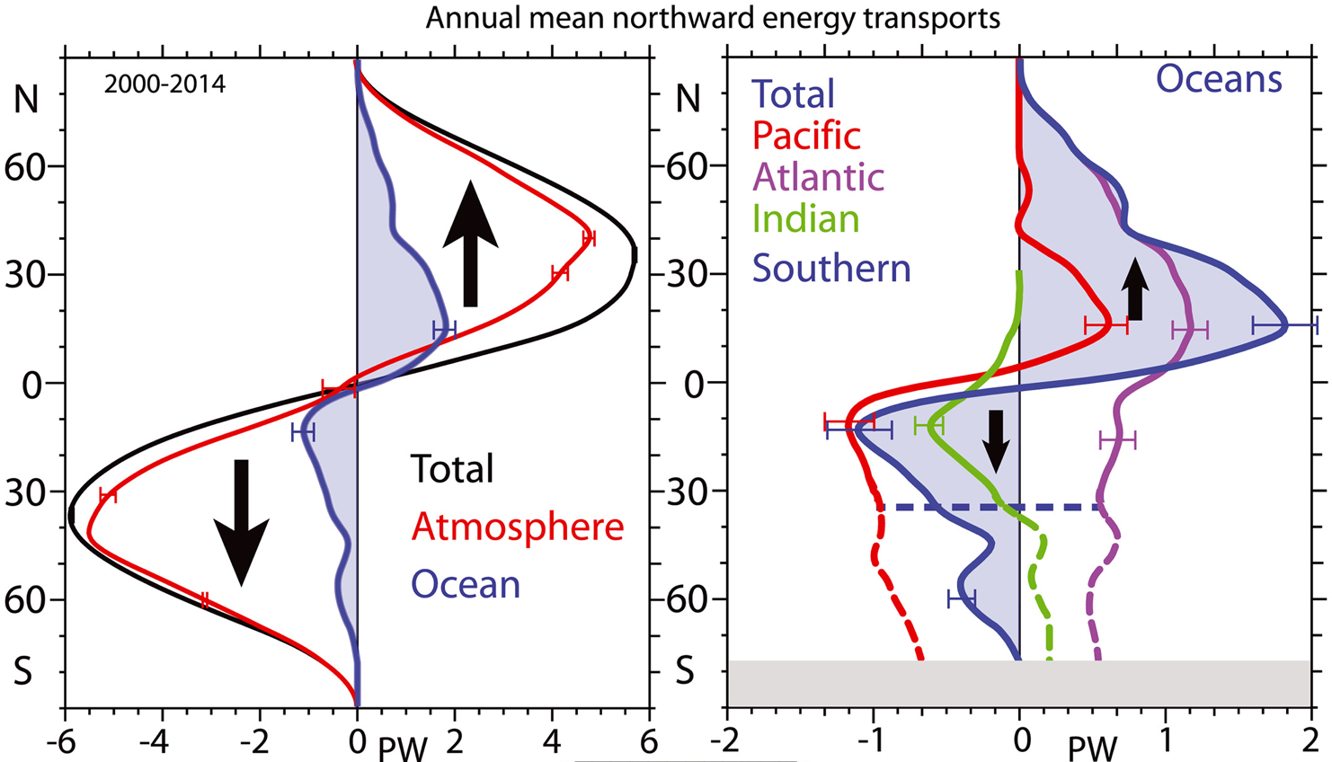
Average annual heat flow to the north. On the left — general (black line), in the atmosphere (red), and the ocean (blue). On the right is the heat flow in the various oceans (in petawatts). Kevin E. Trenberth et al. / Geophysical Research Letters, 2017
The flow of the Gulf Stream itself in the area of the Straits of Florida is also about 1.3 petawatts, so the transfer values themselves do not provide an unambiguous answer about the role of this current in the warming of Europe. They also do not answer the question of why winters in Europe are much milder than in North America at the same latitude. To do this, we need to understand how atmospheric heat transfer works in temperate latitudes.
In the temperate latitudes of both hemispheres, westerly transport of air masses predominates. This is due, firstly, to the temperature gradient between the subtropics and the polar regions (which determines the movement of air towards the poles) — and secondly, to the rotation of the planet, which deflects this flow to the right in the northern hemisphere and the left in the southern. So in temperate latitudes, the flow of warm air towards the poles becomes the westerly wind.
The western wind causes the predominance of a maritime climate in the western parts of the continents and a continental climate in the eastern parts. The global heat flux from the ocean to land in December and January reaches six petawatts (which is comparable to the maximum of meridional heat transfer). Moreover, the warm ocean, mountain ranges, and cooling of the snow-covered surface in winter lead to more frequent formation of cyclones and anticyclones in the same places. If they are averaged over the winter, it may seem that cyclones over the Atlantic and Pacific Oceans (Icelandic and Aleutian lows) and anticyclones over the continents (Canadian and Siberian highs) standstill. As a result, the air no longer moves strictly from west to east, but acquires a meridional component: it comes to the western coasts of the continents from the southwest, from the warm ocean, and to the eastern coasts — from the northeast, from the central cold regions of the continents.
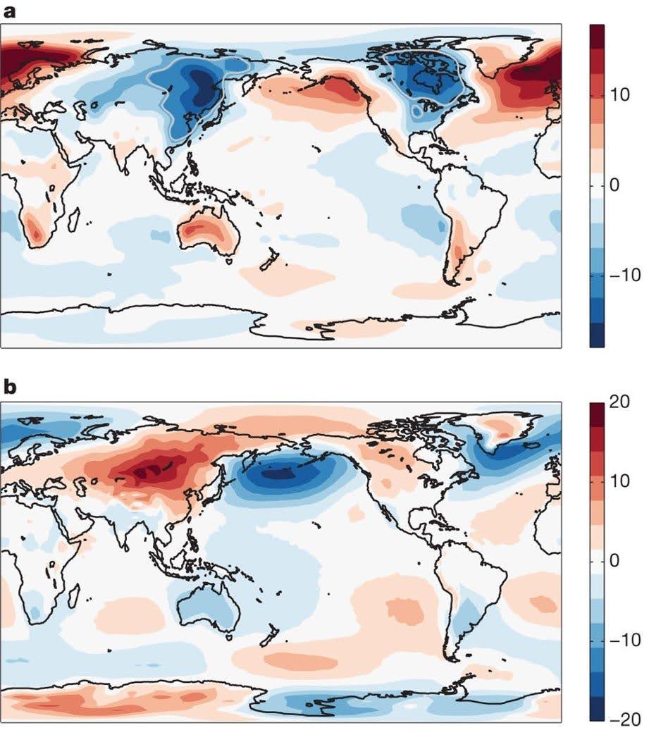
Deviations of surface air temperature (top, ºC) and atmospheric pressure (bottom, hectopascals) from the zonal average values in the winter months (December–February). Yohai Kaspi et al. / Nature, 2011
At the beginning of this century, British meteorologist Richard Seager and his colleagues asked the question: is the Gulf Stream necessary for warm weather in Europe? And they tried to test this using idealized experiments in which all currents in the Atlantic were turned off. It turned out that even if the ocean is “flat,” that is, it does not tolerate heat, and Europe remains significantly warmer than the east coast of the United States. The configuration of atmospheric transport and the exchange of heat and moisture between the ocean and the atmosphere turned out to be critical for the temperature regime of Europe. That is, in the “heating” of Europe, the ocean acts as a battery, which is charged with the heat of the Sun during the summer and releases it in the winter. The services of internal currents in this battery to the European climate are overestimated.
You can, of course, say that this is just simulation data. What do the observations say? Scientists used the back-trajectory method to study winter weather in four European cities — Dublin, Paris, Lisbon, and Toulouse. It turned out that turbulent flows of heat and moisture from the ocean saturate the air masses passing over the sea surface. However, the weather in the cities studied primarily responded not to the temperature of the ocean surface, but to the temperature and humidity of air masses. Moreover, in the years when westerly winds passed over the Gulf Stream and its extension, they did not become warmer and wetter than usual.
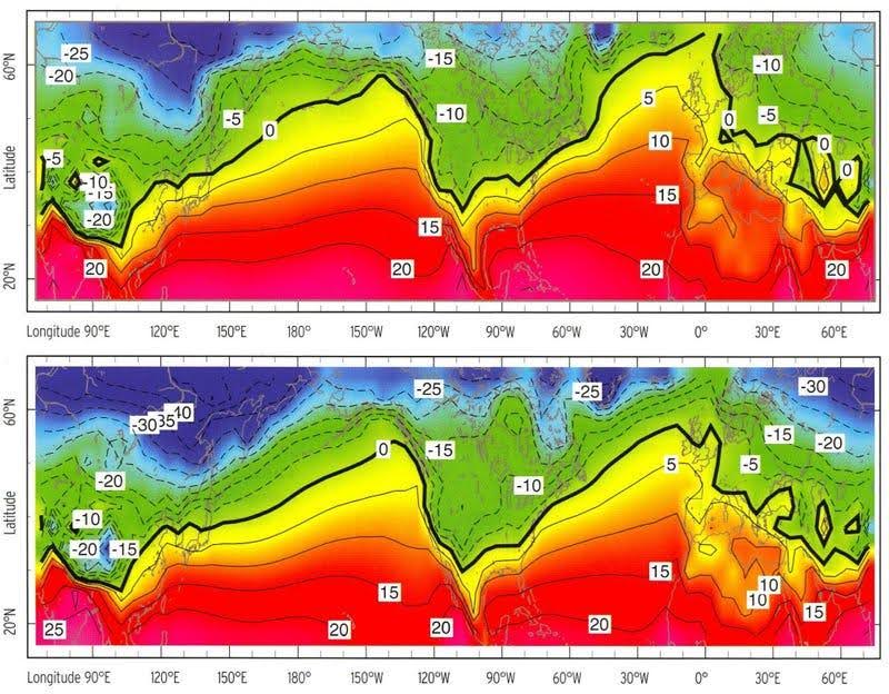
January air temperature in an experiment with ocean heat transfer on (top) and off (bottom). Richard Seager / The Plantsman, 2008
Other studies have shown that sharp boundaries of water temperature in the Gulf Stream region lead to the emergence of powerful upward air movements (convection), heavy precipitation, and the formation of high cold clouds. This in turn triggers disturbances in the atmosphere that are felt in remote areas.
For example, the position of the Gulf Stream affects the intensity of anticyclones over Greenland: the further north the current path, the more intense the anticyclones. Also, the shift of the Gulf Stream affects the temperature in the Barents Sea. But this cannot explain the warm European winters. Moreover, some works (1, 2, 3) based on shear correlation have shown that the position of the Gulf Stream itself depends on air circulation in the Northern Hemisphere.
However, it is known that flows between the ocean and the atmosphere are regulated by changes in the atmosphere over short time intervals (up to ten years), but over long time intervals they are regulated by changes in the ocean. In addition, if you look closely at the modeling results of Seager and his colleagues, you can see that the temperature of northern Europe is significantly affected by turning on and off the currents. That is, the Gulf Stream still heats Norway?
The general circulation in the Atlantic is important here. The Gulf Stream is only part of it — the most visible and best known, but not the determining one. Moreover, the connection of the Gulf Stream with its continuations is not so obvious.
illuminem Voices is a democratic space presenting the thoughts and opinions of leading Sustainability & Energy writers, their opinions do not necessarily represent those of illuminem.
Steve Harding

Water · Nature
Diego Balverde

Effects · Water
Praveen Gupta

Effects · Mitigation
Financial Times

Power & Utilities · Water
BBC

Nature · Water
Eurasia Review

Carbon Capture & Storage · Water